No accident: Syria deliberately bombed schools and water supply
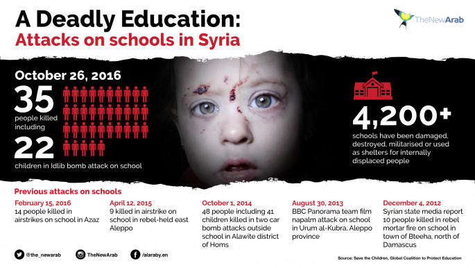
A UN commission on the Syrian war says it believes government forces deliberately bombed a school complex in the country's northern countryside, killing 21 children, last October.
The UN's Independent International Commission of Inquiry on Syria said the Syrian military is the only country known to operate the jets identified in the attack.
The commission said on Tuesday the attack on the Haas village school complex in the rebel-held province of Idlib constituted a war crime. The attack was widely reported at the time.
The report also concluded that government forces deliberately targeted the capital's water supply infrastructure last December, threatening water supplies to 5.5 million people.
It said the attack was unjustified, and constituted a war crime. It did not find any evidence that rebels had poisoned the water supply, as the Syrian regime claimed at the time.
Rebels had controlled the springs of the Wadi Barada valley, northwest of Damascus since 2012 and faced a major offensive by Syrian government forces and their allies, despite a ceasefire deal. The rebels withdrew at the end of January.
Bombing the water well
The commission, led by Brazilian investigator Paulo Pinheiro, said there were no reports of people suffering water contamination on or before Dec. 23, when the Syrian air force hit al-Fija spring with at least two airstrikes.
 |
| [Click to enlarge] |
"While the presence of armed group fighters at (the) spring constituted a military target, the extensive damage inflicted to the spring had a devastating impact on more than five million civilians in both government and opposition controlled areas who were deprived of regular access to potable water for over one month," the commission's report said.
"The attack amounts to the war crime of attacking objects indispensable for the survival of the civilian population, and further violated the principle of proportionality in attacks."
The commission's conclusions were based on interviews with residents and satellite imagery, as well as publicly available information.

![Palestinians mourned the victims of an Israeli strike on Deir al-Balah [Getty]](/sites/default/files/styles/image_684x385/public/2024-11/GettyImages-2182362043.jpg?h=199d8c1f&itok=xSHZFbmc)


![The law could be enforced against teachers without prior notice [Getty]](/sites/default/files/styles/image_684x385/public/2178740715.jpeg?h=a5f2f23a&itok=hnqrCS4x)
 Follow the Middle East's top stories in English at The New Arab on Google News


