Israel presses ahead with controversial E1 settlement plan, with separate road system
Talk of annexation may be off the table, but it is very much happening on the ground. Infrastructure works to boost illegal Jewish settlements in the occupied West Bank are in high gear.
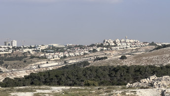
The Israeli military has drawn plans for a new bypass road connecting Ezariyah with Al-Zaiem, two Palestinian towns near occupied East Jerusalem. Upon completion, the Israeli army would shut down the Eastern edge of Eazriyah near the Ma'ale Adumim settlement in front of Palestinian traffic and leave the road for the sole use of Jewish settlers.
The implications are far-reaching; a sizeable chunk of ground in the centre of the occupied West Bank would become inaccessible to Palestinians while leaving free movement between the Jewish settlements of Ma'ale Adumim and Mishor Adumim and Jerusalem. Further, the checkpoint currently in place near Al-Zaiem would be moved several kilometres away, deep in the West Bank, effectively allowing Israel to annex the string of Jewish settlements in the area.
The planned road is linked to an old Israeli scheme called E1 that envisions the construction of thousands of housing units for Jewish settlers next to the Ma'ale Adumim settlement and connecting them to occupied East Jerusalem.
Settlement construction in the E1 area is seen by Palestinians and proponents of the two-state solution as a threat to the territorial contiguity critical for a viable independent Palestinian state by dividing the north of the West Bank from the south and the West Bank from East Jerusalem.
Traffic on this road would be allowed for Jewish settlers only once a bypass road for Palestinians is built, 8 May 2023.
[Ibrahim Husseini/TNA]
Issam Faroun, the former mayor of Ezariyah, described Israel's plan as "dangerous" to the prospects of a two-state solution on land Israel occupied in 1967.
The E1 furthers the isolation of East Jerusalem from the rest of the West Bank by creating more Jewish settlements around it.
"The location of E1 connects three areas; Ramallah, Jericho and Bethlehem," Faroun told The New Arab.
Israel's E1 plan, he warned, "would end the contiguity between these three areas and would shut the historic road connecting East Jerusalem to Eazariyah and Jericho."
Peace Now, an Israeli NGO that backs a two-state solution to the Israeli-Palestinian conflict, warned in a recent report that the Israeli government's plan amounts to "apartheid and annexation."
"The paving of the road will create a separate road system for Israelis and Palestinians (an "apartheid" road)," the anti-settlement Israeli NGO Peace Now said.
Removing the checkpoint would enable continuous movement for Ma'ale Adumim settlers and the surrounding area to Jerusalem... without the feeling that they are living outside the borders of the State of Israel," the Peace Now statement added.
E1, short for East 1, is a 12 square kilometre block of land between East Jerusalem and Ma'ale Adumim that falls within the jurisdiction of Ma'ale Adumim. It borders the Palestinian towns of Anata, Abu Dis, Eizariya and Al-Zaiem, past the eastern border of the Municipality of Jerusalem.
The E1 settlement plan would directly impact the dozens of Bedouin communities in the area, including the Bedouin of Khan-al-Ahmar, by cutting them off from the rest of the West Bank.
"The Bedouin of Khan al-Ahmar and other Bedouin communities would become isolated and their movement restricted. This would pave the way for their removal," Faroun warned.
The communities of Wadi Jimel and Jabal Al-Baba living near the planned road will also be separated from their surroundings if the road is constructed.
Strong international opposition, including from the United States, has in the past deterred Israel from going forward with E1. This may change, however. As the ruling coalition shows signs of strain, Israeli PM Netanyahu may see a need to appease his coalition partners and allow E1 to materialise.
Israel occupied the West Bank, including East Jerusalem, during the 1967 war. Over half a million Israeli settlers live in the West Bank and East Jerusalem. Settlements are illegal and considered a war crime under international law.


 Follow the Middle East's top stories in English at The New Arab on Google News


![A group of Palestinians, foreign and Israeli activists gather to participated in an olive picking event on the land in the town of Battir, which is under threat of confiscation by Israel in Bethlehem, occupied West Bank on 8 November 2024. [Getty]](/sites/default/files/styles/image_330x185/public/2182930803.jpeg?h=199d8c1f&itok=__0LgGsa)