A no man's land: Travelling around the West Bank after nine years
The Israeli settlement project in the West Bank has ballooned from the ramshackle grey trailers, haphazardly stacked on hilltops above roads winding through Area C connecting Palestinian cities in Area A, to more permanent red-roofed American-style suburban villas.
These are now built alongside the trailers of the early days of the West Bank's military occupation, mutating into lines of concrete apartment blocks seemingly inspired by Mussolini-era Italian architecture. They advance down the ancient terraced hills to the roadsides marked by tall poles flying the Israeli flag positioned at regular intervals along Palestinian highways.
Ariel Sharon's hill-top youth settler movement started in defiance of international law and has expanded as now-middle-aged suburbanites become a population of illegal apartment dwellers.
The Israelis refuse to see or accept their status as occupier and actively work as a force for annexation, with the ideology that this land will one day be theirs - or, for many, that it already is.
The Israeli state has constructed an extensive road-building programme in the Palestinian West Bank to link the settlements with Israel; roads that divide Palestinian villages from their farmlands.
 |
The Israelis refuse to see or accept their status as occupier and actively work as a force for annexation, with the ideology that this land will one day be theirs - or, for many, that it already is |  |
Currently the Israeli state is tunnelling through West Bank hills to build an underground railway to link Ariel settlement with Tel Aviv. This will further blur the boundaries of the state of Israel, further absorbing the territory that has been set aside for a future Palestinian state.
The Israeli road and settlement building programmes cause all kinds of confusion in what is a very small geographic area. The use and control of that space is divided along ethnic lines by the most powerful party to the conflict - the Israeli state.
 |
|
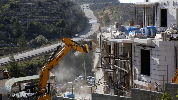
| An Israeli hydraulic shovel demolishes a Palestinian building near road 35, north of the occupied West Bank city of Hebron, in the so-called 'Area C' where Israel exercises full control and demolishes buildings constructed without the required Israeli permits, which are almost never granted to Palestinians [Getty] |
As I look out of the car window when travelling through the West Bank, I see road signs throughout Area C written in Arabic and Hebrew. But the place names show only the Israeli settlement towns and the billboards in Area C advertise products in Hebrew.
The settlement projects plant non-native Italian pine trees on the slopes surrounding the settlements, that, it turns out, are wild fire hazards.
An ancient olive tree has been uprooted and transplanted onto a roundabout near the entrance of Ma'ale Adumim just north of Al-Eizariya, a Palestinian town divided on paper into Areas B and C by the Oslo administrative lines.
The olive tree is supposed to imply the Israelis' ancient connection with the land of Palestine.
Read also: How Israel is uprooting West Bank's future
We leave the bright green grass of the roundabout and drive into Al-Eizariya, which is on a bleak road made of car breakers and landfill sites and highly polluted with all kinds of toxic waste.
It is an semi-urban industrial environment where the Palestinian Authority has no mandate and the Israelis only involve themselves in the so-called "terror" issues.
All kinds of nefarious trades are said to be plied that are illegal in Israel and in areas under the Palestinian Authority. It is a no-man's-land in some respects, a haphazard frontier marked by the mountains of broken cars and heaps of what looks like smashed up asbestos.
This is the area outside the city I am told has been set aside for the future "Palestinian Jerusalem" and it includes a steep canyon valley where effluent and waste is pumped and excreted daily.
 |
As roads multiply in the West Bank, so does pollution and traffic |  |
Since I was last in the West Bank in 2009, road traffic has multiplied. One of the main reasons is the cheap credit that is being made available to buy cars. One of my interviewees told me that her husband took out a loan, because "it is good for a man to have a car". She added that having a car was useful for families living in remote areas.
But as roads multiply in the West Bank, so does pollution and traffic.
One effect I experience when travelling on the new roads is that of disorientation. I wondered how these re-routes impact Palestinian trade and livelihoods.
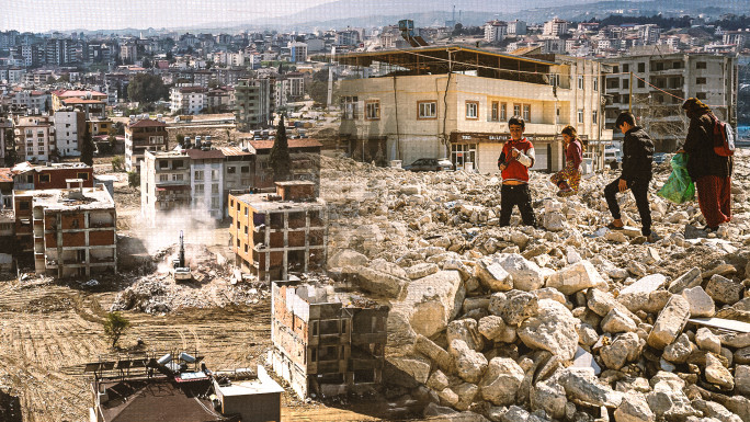
For many Palestinians, real estate is their only security, but due to building restrictions in Area C, the green spaces in Areas B and A are rapidly vanishing under ugly concrete buildings.
 |
For many Palestinians, real estate is their only security |  |
At the Palestinian Natural History Museum in the Bethlehem area, I somehow found myself showing a Palestinian scientist, her husband and children the exhibits, papers and books by the museum's founder Dr Mazin Qumsiyeh.
We visit the owl kept in an aviary on the edge of the hill overlooking Bethlehem and Beit Sahour. The scientist grabs a handful of dried grass seed from a golden stalk and throws it up in the air.
"We used to throw grass seed on the backs of each other's shirts when we played in the meadows around Bethlehem," she tells me.
"We used to say that the amount of seeds that stuck to our backs were the amount of years we were going to live.
"My children don't get to play games like that. In fact they don't play outside much at all. We are losing all our green space. This is why I brought the children to the museum today, so they could learn something about nature."
CJ Weaver is a researcher and writer specialising in Middle East conflicts, currently based in the occupied West Bank.


 Follow the Middle East's top stories in English at The New Arab on Google News


