Aleppo aid convoy was 'hit by airstrike' says UN
A UN expert said that satellite images of a deadly attack on an aid convoy in Syria shows that it was caused by air raids.
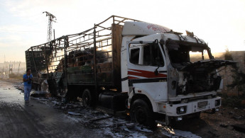
Last month's attack killed some 20 people who were driving and facilitating the joint UN and Syrian Arab Red Crescent convoy near Syria's second city of Aleppo.
The devastation also destroyed 18 of the convoy's 31 trucks, a warehouse and a clinic.
Damascus and Moscow have blamed rebels for the attack on the convoy, but eyewitnesses and monitors insist the damage was caused by aerial bombing - and almost certainly by Russian and regime war planes.
"We had an image of that and could clearly see the damage there. With our analysis we determined it was an airstrike and I think multiple other sources have said that as well," Lars Bromley, research adviser at UNOSAT, told reporters.
"For airstrikes, what you are usually looking out for is the size of the crater that is visible and the type of crater," he said.
A giant crater was caused "almost certainly (by) air dropped munitions" as opposed to artillery or mortars, he said.
The US has held Russia responsible for the bombings, which broke a truce brokered by the two countries and led to a massive bombardment by regime war planes on opposition areas.
The United Nations has only referred to ot as an "attack" and briefly suspended convoys in Syria. The International Federation of Red Cross and Red Crescent Societies initially referred to "airstrikes" in a statement.
Read also: In pictures, a short walk around an Aleppo neighbourhood
The UN said there would be an internal board of inquiry to investigate the attack and urged all parties to fully cooperate.
UNOSAT (UN Operational Satellite Applications Program), looks at commercially available satellite images, and has not been asked to share its analysis with the UN investigators but said willing to do so.
Einar Bjorgo from the group said, "Our images are from time to time used in order to brief Security Council members."
Bjorgo, speaking generally, said: "We are neutral. We don't have a political agenda, we simply state the facts."
UNOSAT has mapped Syria's conflict since it began in 2011, often using radar satellites that look through clouds to assess population movements and damage to civilian infrastructure.
This enables UN agencies trying to deliver food and medical assistance to besieged areas to view roadblocks and checkpoints in real time.
Bromley, referring to rebel-held eastern Aleppo that has been pummeled by Syrian and Russian aircraft for the last 10 days, said:
"What you see is (that) formerly blasted and blown up areas are experiencing a great deal of additional damage. So it's actually hard to do the analysis because to a certain extent you are looking at rubble being pushed around. But it's certainly highly visible."


 Follow the Middle East's top stories in English at The New Arab on Google News
![The UAE is widely suspected of arming the RSF militia [Getty]](/sites/default/files/styles/image_330x185/public/2024-11/GettyImages-472529908.jpg?h=69f2b9d0&itok=Yauw3YTG)
![Netanyahu furiously denounced the ICC [Getty]](/sites/default/files/styles/image_330x185/public/2024-11/GettyImages-2169352575.jpg?h=199d8c1f&itok=-vRiruf5)
![Both Hamas and the Palestinian Authority welcomed the ICC arrest warrants [Getty]](/sites/default/files/styles/image_330x185/public/2024-11/GettyImages-2178351173.jpg?h=199d8c1f&itok=TV858iVg)